


Scientists from the National Aeronautics and Space Administration and the National Oceanic and Atmospheric Administration have discovered significant shifts in the coastal land of California. Some areas are either sinking or rising. These shifts will affect how different communities across the state will experience sea level rise, flooding, and saltwater intrusion.
Latest Maps from NASA and NOAA Identified Areas in California that Are Sinking and Rising: How Vertical Land Motion is Reshaping the Future of California
Background
Traditional sea level rise projections often underestimate the impact of VLM or vertical land motion. Most existing models, including those in the United Nations Intergovernmental Panel on Climate Change or IPCC Sixth Assessment Report, depend on regional linear estimates. These estimates do not capture complex and localized changes in land elevation.
Nevertheless, a team of scientists from NASA and NOAA wanted to provide localized estimates of land subsidence and uplift to enhance sea level rise projections. They focused on California for this undertaking. The main goal was to pinpoint specific regions or areas across the state and determine factors that drive land elevation changes through localized associations.
The team studied high-resolution satellite data from 2015 to 2023 from the Sentile-1 satellites of the European Space Administration and ground-based Global Navigation Satellite or GPS stations. They used interferometric synthetic aperture radar or InSAR. This is a remote sensing technique that processes multiple 3D satellite images to track surface movement.
Specific Findings
Findings showed that the land beneath major coastal cities, including parts of San Francisco, Los Angeles, and San Diego, is undergoing a higher level of subsidence, while some areas are experiencing uplift. These land movements can significantly impact coastal planning and flood mitigation efforts. Sinking areas are at higher risk of flooding and sea level rise.
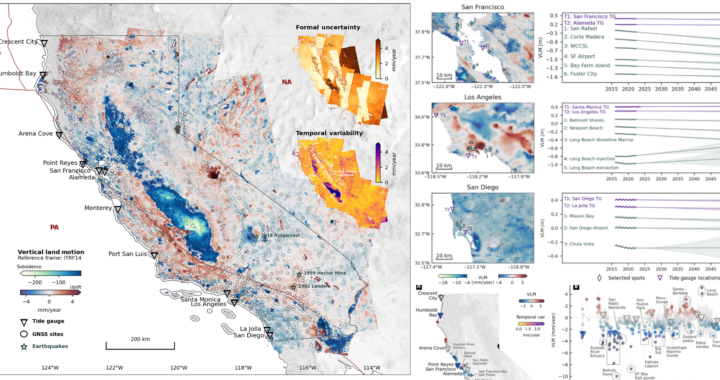
The team of researchers pinpointed affected areas in a series of maps that are included in the 2025 article which was published in Science Advances. The blue areas indicate subsidence. Darker shades of blue represent specific areas that are sinking faster. Red marks indicate lands that are rising. Darker shades of red represent particular areas experiencing faster uplift.
Hence, based on the maps, the most prominent area of rapid subsidence is the Central Valley, particularly the region south of Fresno, and includes the Tulare Basin. The coastal mountain ranges, such as those stretching north and south of San Francisco more rapid uplift. Some areas along the western foothills of the Sierra Nevada are also experiencing faster uplift.
Implications
Further findings revealed that the causes of subsidence or sinking are linked to soil compaction, erosion, and groundwater withdrawal. These are common in Central Valley because this area is a vast sedimentary basin filled with layers of clay, silt, and sand. There are also intensive agricultural activities in the area that have necessitated excessive groundwater extraction.
The causes of uplift are observed in areas like Long Beach. The researchers noted that oil and gas extractions in these areas are critical. These activities involve introducing water or steam into the reservoir. The added pressure lifts the surface. Tectonic activities in the coastal mountain ranges, including those in San Francisco, could also be one of the main reasons for uplift.
Some areas in Los Angeles and San Diego could see double the expected sea level rise by 2050 due to the rate at which they are sinking. Nevertheless, based on the visualized maps, the findings underscore the need to include local vertical land motion data in sea level rise assessments. These data are considered critical for future community planning and climate adaptation.
FURTHER READING AND REFERENCE
- Govorcin, M., Bekaert, D. P. S., Hamlington, B. D., Sangha, S. S., and Sweet, W. 2025. “Variable Vertical Land Motion and Its Impacts on Sea Level Rise Projections.” In Science Advances. 11(5). American Association for the Advancement of Science. DOI: 1126/sciadv.ads8163